“Over the years we’ve invested significantly in our field data team - focusing on producing trusted ratings. While this ensures the accuracy of our Ratings, it doesn’t allow the scale across the thousands of projects that buyers are considering.”

For more information on carbon credit procurement trends, read our "Key Takeaways for 2025" article. We share five, data-backed tips to improve your procurement strategy.

One more thing: Connect to Supply customers also get access to the rest of Sylvera's tools. That means you can easily see project ratings and evaluate an individual project's strengths, procure quality carbon credits, and even monitor project activity (particularly if you’ve invested at the pre-issuance stage.)
Book a free demo of Sylvera to see our platform's procurement and reporting features in action.
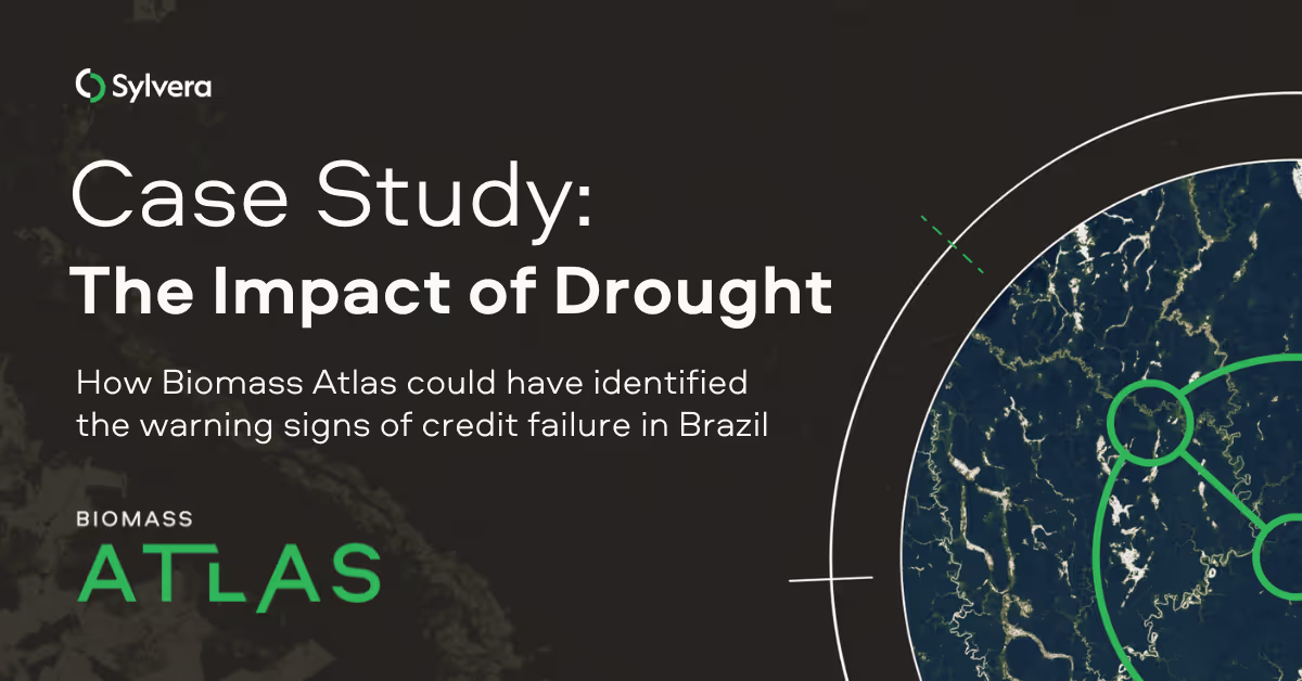
Background
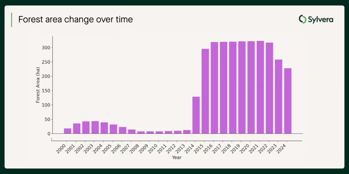
The project in question is an exotic forest project in Brazil, covering over 300 hectares. Prior to the project's start in 2015, the area consisted of degraded grasslands used for low-productivity extensive cattle ranching, a practice that historically involved burning to stimulate pasture regrowth. The project design itself contained ambiguities, including conflicting statements regarding whether harvesting would be conducted and included in the project.
The planting of Eucalyptus spp. trees in monoculture stands, which is generally a practice associated with commercial harvesting operations, suggested potential harvesting intent. However, the project documentation lacked information regarding a planned harvesting structure, details on replanting, or inclusion of a long-term average (LTA).
The project’s strategy initially appeared successful; during the first monitoring period (April 2015 to July 2020), independent auditors verified that the project had sequestered 124,649 tCO2e and was compliant with VCS standards. However, the project subsequently suffered a significant reversal, due to an extreme and prolonged drought that impacted the region between 2019 and 2023.
Identified as one of the worst drought events in 40 years, the lack of rainfall caused widespread tree mortality - exacerbated here because of the planting of exotic, non-native trees - that exceeded the project's ability to recover through standard silvicultural interventions.
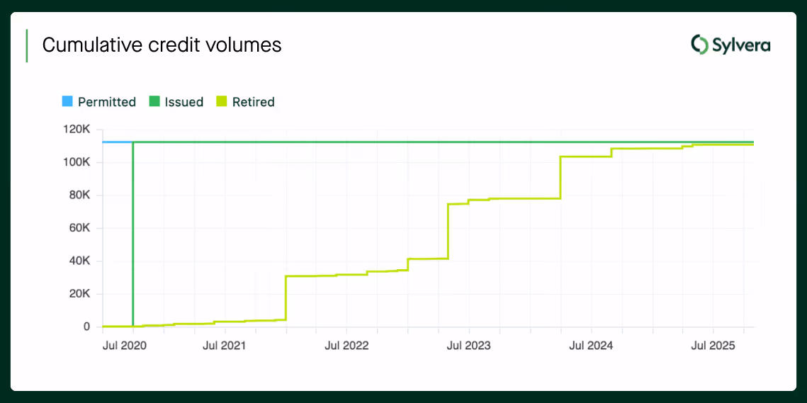
The project is now effectively stalled. Experts deemed the planted cultivars unsuitable for the altering climate, and the owners lacked the funds to replant with drought-tolerant variants. A Loss Event Report identified that carbon loss (17,000+ tCO2e) exceeded the accumulated credits in the risk buffer pool, resulting in a deficit for the project.
However, credits were still being retired in 2023 and beyond. Buyers were retiring them, confident in the corresponding climate impact, whereas in reality they were essentially worthless investments.
So, could Biomass Atlas have identified the warning signs before this failure?
The challenge: Critical blind spots
Nature-based carbon projects face a fundamental verification problem. Traditional monitoring typically occurs every 5-7 years through expensive, limited field surveys. When problems emerge, they're often discovered and subsequently reported too late.
With the project in question, these were:
- Eligibility questions that could have been highlighted at project start
- No independent confirmation that the claimed early removals were genuinely occurring between audits
- Undetected losses from drought that rendered credit retirements ineffective
Insights that using Biomass Atlas would have provided
We analyzed the project using Biomass Atlas's 25-year historical dataset and annual monitoring capability. The results reveal what continuous, independent verification would have shown at three critical junctures.
Finding 1: Ineligible land included in the project boundary
Pre-2015 (before project start)
What canopy height data from Biomass Atlas detected:
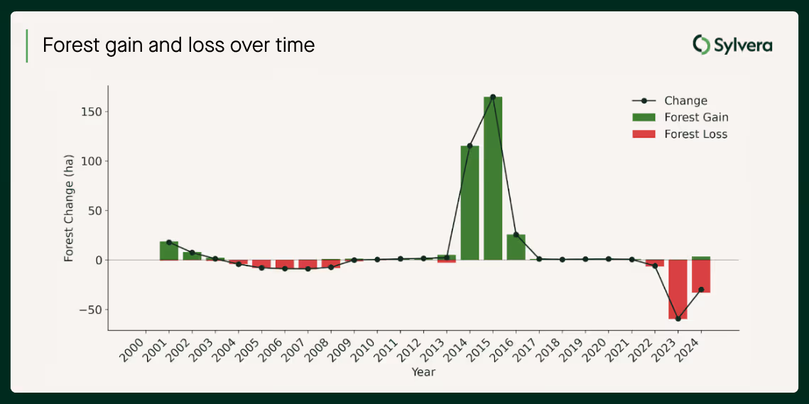
- Meaningful deforestation (~10% of the project area) occurred in the 10 years before project start across parcels of the planned project area
Why this matters: Many methodologies (e.g., VM0047) permit ARR projects being established on only non-forest, or forests that have not been managed for wood products in the past 10 years. This is to avoid perverse incentives and protect mature ecosystems (e.g., discourage clearing of existing forests), and ensure additionality.
The outcome: Under current VM0047 requirements (versus the older AR-ACM0003 that this project used), Biomass Atlas would have identified these parcels as ineligible for crediting. Credits issued from these parcels would then never enter the market.
Finding 2: Independent data confirms the initial carbon benefit
2015-2020 (First monitoring period)
What Biomass Atlas detected: Across the first monitoring period, Biomass Atlas measures carbon-stock growth consistent with the project's claims — the developer's figure of 70.34 tCO2e/yr/ha falls within the field-validated estimate range 69.0 ± 12.6 tCO₂e/yr/ha. The credits issued in this window broadly represented the tonnage they were sold as.
Why this matters: A credible monitoring dataset has to confirm genuine performance as readily as it flags problems. Here, independent lidar-trained measurement corroborates that planting succeeded and the early vintages delivered close to their buffer-discounted ~1 tCO2e — the project delivered the carbon it sold, at least initially. But a credit has to represent a lasting removal. We can use the same dataset to track what happens next.
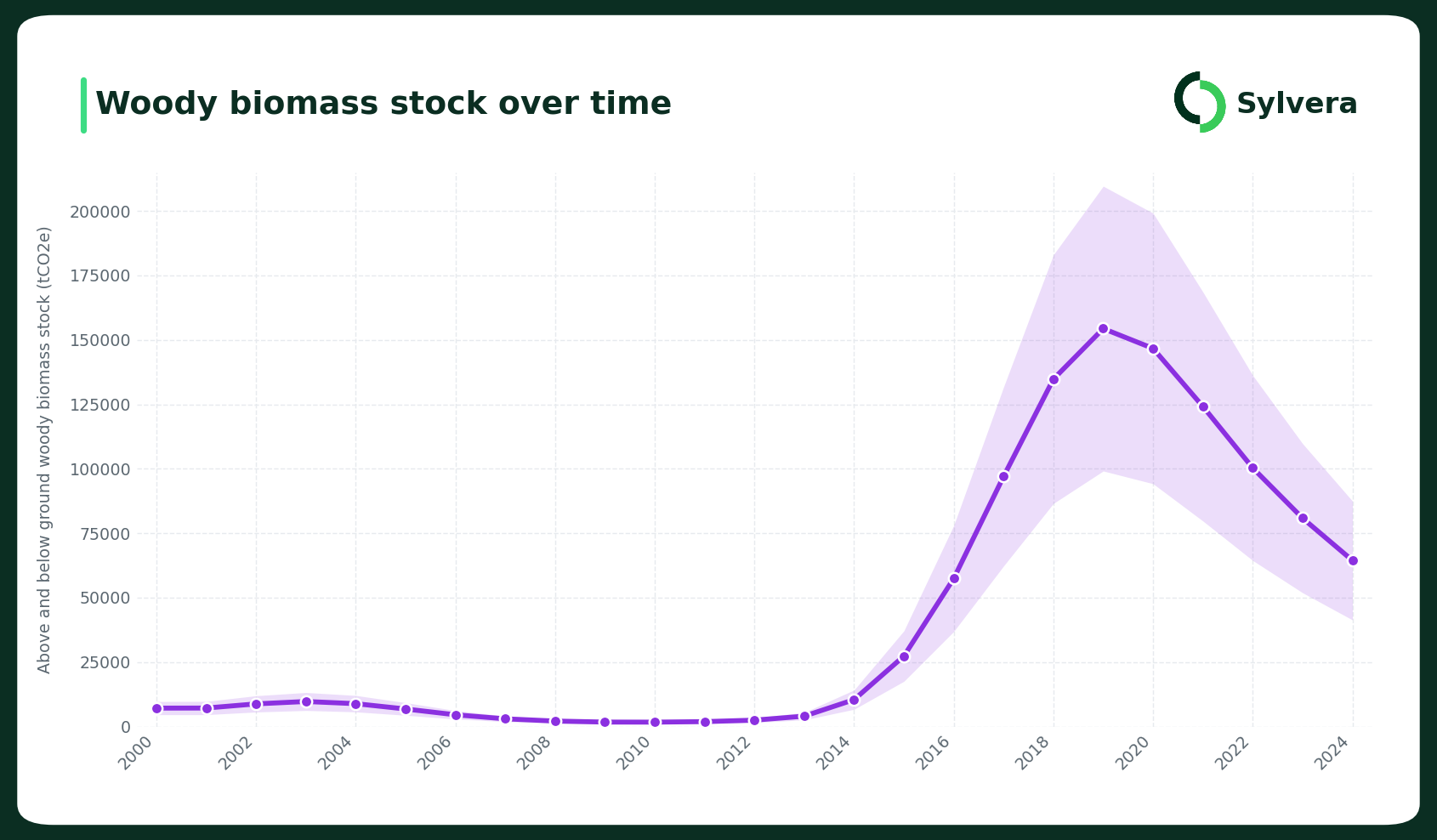
Finding 3: Losses went undetected whilst retirements continued
2021 - 2023 (Drought and continued retirements)
What Biomass Atlas detected:
- Between 2021 and 2023, widespread tree mortality caused carbon losses of 17,942 tCO2e reported by the developer - exceeding the project's accumulated buffer pool and leaving it in deficit.
- Biomass Atlas identified these losses that could have prevented wasteful investment and retirements from 2023 onwards.
Why this matters: The majority of credit retirements from this project happened in 2023 and beyond - after the losses could have been detected. Retirees were unaware that their credits represented zero climate benefit.
The timeline failure: Traditional verification operates on 5-7 year cycles. By the time the Loss Event Report was filed, credits had already been sold and retired. Biomass Atlas's annual monitoring would have identified losses in real-time, preventing these retirements.
The full picture: why the good and the bad both need continuous data
This wasn't a single event — it was a flawed baseline, a period of genuine delivery, and a catastrophic reversal, none of which traditional monitoring could resolve in time:
Stage 1 (Pre-2015): Ineligible land included → Invalid baseline
Stage 2 (2015–2020): Genuine early delivery → real, but unverifiable under developer-reported monitoring
Stage 3 (2021-2023): Drought losses undetected → Deficient retirements
At each stage, independent verification with Biomass Atlas would have:
- Caught eligibility issues before the project was registered
- Independently confirmed the early removals
- Detected losses in real-time before 2023 retirements
Why traditional methods failed
Traditional ARR project monitoring relies on:
- Limited plot sampling covering a tiny minority of the project area
- 5-7 year verification cycles with no continuous monitoring
- Allometric equations that can introduce systematic error
- Developer-provided data with limited independent verification between audits
This approach worked when carbon markets were small and slow-moving. It fails when projects face rapid climate effects (drought, fire, disease), retirements happen faster than verification cycles, and buyers need real-time assurance of credit integrity.
How Biomass Atlas delivers continuous verification
Biomass Atlas provides the verification infrastructure that this project needed:
Historical validation (2000-present)
Verify project eligibility with 25 years of historic data. Identify ineligible parcels before registration, not after credit issuance.
Annual monitoring
Track biomass changes every year, not every 5-7 years. Detect losses owing to drought, fire, or harvest events in the same year they occur.
Independent measurement
Every pixel includes uncertainty estimates. Understand confidence levels and avoid inflated removal claims. No dependence on developer-provided estimates.
Biomass Atlas sets a new standard for project integrity
Traditional biomass datasets rely on allometric models with large uncertainties and potential biases, as well as on infrequent field surveys that miss rapid changes. Biomass Atlas is built to eradicate this uncertainty.
Over four years, Sylvera invested over $10 million collecting proprietary multi-scale lidar data across 250,000+ hectares on five continents. This approach combines:
Terrestrial Laser Scanning (TLS)
3D tree modeling across 1-hectare plots. Direct measurement of tree volume—no allometric equations.
Airborne Laser Scanning (ALS)
Helicopter-based laser scanning at ~160m altitude. Wall-to-wall regional coverage at 300 pts/m2 density with survey-grade georeferencing accuracy.
This multi-scale approach provides field-validated reference data that's used to train satellite-based models. The result: errors below 9% at typical project scales (400-7,000 hectares), 25 years of historical validation data, and annual monitoring that detects change events in real-time.
Accurate, defensible carbon stock data for your project
This project demonstrates the potential impact of verification infrastructure lagging behind market needs. The same credits went from sound to worthless, and only continuous, independent verification would have told buyers when.
For project developers, this is the difference between legitimate credits and project failure. For registries, it's the difference between market integrity and reputational damage. For buyers, it's the difference between real climate impact and greenwashing.