“Over the years we’ve invested significantly in our field data team - focusing on producing trusted ratings. While this ensures the accuracy of our Ratings, it doesn’t allow the scale across the thousands of projects that buyers are considering.”

For more information on carbon credit procurement trends, read our "Key Takeaways for 2025" article. We share five, data-backed tips to improve your procurement strategy.

One more thing: Connect to Supply customers also get access to the rest of Sylvera's tools. That means you can easily see project ratings and evaluate an individual project's strengths, procure quality carbon credits, and even monitor project activity (particularly if you’ve invested at the pre-issuance stage.)
Book a free demo of Sylvera to see our platform's procurement and reporting features in action.
Forest carbon measurement has long relied on assumptions, estimates, and one-size-fits-all formulas.
But what if we could measure each tree with millimeter precision? What if we could capture the true structural complexity of forests rather than relying on simplified models? Terrestrial lidar makes this possible, transforming how we quantify, verify, and monitor carbon stored in forests.
In this article, we explain what terrestrial lidar is, how this remote sensing technology works and leads to more accurate imaging for carbon measurement purposes, and much more.
Terrestrial lidar 101
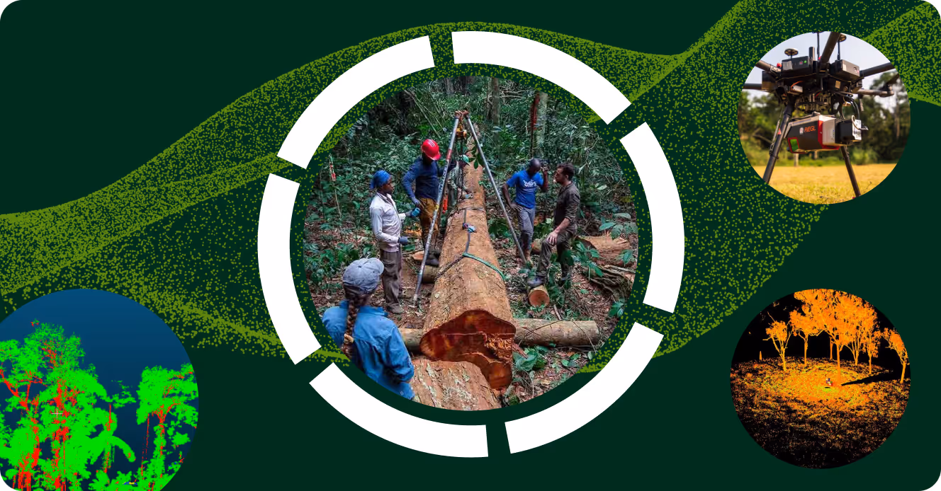
The term "lidar" stands for "Light Detection and Ranging". This technology uses laser pulses to measure distances with extraordinary precision, and it can be deployed in a variety of ways.
For example, airborne and satellite lidar systems capture broad landscapes from above. Terrestrial lidar systems, often referred to as terrestrial laser scanners (TLS), work from the ground up. This ground-based approach delivers something different: ultra-dense 3D point clouds that capture every branch, gap in the canopy, and structural detail that affects carbon storage.
As such, lidar sensors reveal the actual shape and size of tree trunks in a forest rather than estimating them from a single diameter measurement. lidar helps map canopy structures too, showing how branches distribute biomass throughout the tree. And we can't forget about gap fractions—the spaces between leaves that affect light penetration and forest growth patterns—which LiDAR also calculates.
Why should you care about this level of detail? Because pinpoint accuracy at the ground level creates a wave of improvements throughout the entire carbon measurement system.
Accurate ground-truth data leads to better carbon estimates, which translates to lower integrity risk in carbon projects and more defensible claims about carbon storage and sequestration rates.
How Does Terrestrial Lidar Work?
The scanner itself combines a high-precision laser with a rotating mirror system that sends light pulses across the forest in a systematic pattern. Multiple scan positions around a piece of land ensure complete coverage, capturing trees from different angles to maximize clarity. Advanced software then stitches these individual scans together into a unified 3D model of the forest plot.
The transformation from raw point cloud data to accurate carbon estimate involves several critical steps. First, tree segmentation algorithms identify individual trees within the dense remote sensing dataset. Then, stem reconstruction techniques build precise 3D models of tree trunks, capturing their actual shape rather than assuming cylindrical geometry. Finally, volume and biomass models convert these precise geometric measurements into trustworthy carbon estimates.
The real magic happens when TLS ground truth details are combined with airborne lidar and satellite imagery. TLS provides the precise plot-level calibration data. Airborne lidar extends coverage across landscapes while maintaining moderate resolution. Satellite and optical data enable monitoring at regional scale with frequent revisit times. Each technology fills gaps in the others' capabilities, creating a comprehensive monitoring system that balances precision with wide-spread coverage.
This Multi-Scale LiDAR (MSL) approach is the foundation of Biomass Atlas. By combining Terrestrial Laser Scanning (TLS), UAV Laser Scanning, and Airborne Laser Scanning (ALS), Biomass Atlas provides wall-to-wall global coverage with unprecedented accuracy—errors below 9% at typical small project scale (400-7,000 hectares).
Why TLS Improves Carbon Measurement Quality
Clearly, scanning every tree in a forest, every forest across an ecosystem, and every ecosystem across the planet, is unrealistic. But there are modern approaches that make estimating these outcomes significantly more accurate.
Traditional forest carbon measurement relies on allometric equations. These generic formulas assume average tree shapes and wood densities, but real forests are far more variable.
TLS eliminates these issues by capturing the actual shape of trees in a forest, including the tapering of tree trunks, the distribution of branches, and the three-dimensional structure that determines biomass. This geometric precision reduces reliance on generic allometric equations and minimizes errors from manual diameter and height measurements. The result? True reality capture.
Understory vegetation represents another source of bias in traditional carbon inventories. Field crews often struggle to measure—or even detect—smaller trees in dense forests. TLS captures this structural heterogeneity automatically, providing complete coverage of all vegetation within the laser's range.
Perhaps most importantly, TLS enables repeatable measurements that track forest changes over time. This is crucial for monitoring growth and disturbance in a way that enables credible carbon accounting.
At the end of the day, the net effect of TLS for monitoring, reporting, and verification (MRV) systems is substantial: tighter confidence intervals around carbon estimates, stronger integrity claims backed by objective data, and better ratings from independent assessment organizations like Sylvera.
Biomass Atlas operationalizes these benefits at global scale. Built on proprietary TLS data from over 25,000 trees across 250,000+ hectares on 5 continents, it provides 3D-explicit modeling where direct measurement of tree volume and biomass requires no allometric equations. This peer-reviewed approach, validated through published research, is trusted by governments and recognized as the industry benchmark by registries like Equitable Earth Registry and the Woodland Carbon Code.
Where TLS Fits in a Modern MRV Stack
When it comes to modern-day MRV for forest-based carbon projects, TLS functions as the ground-truth foundation that enables broader measurement systems.
For plot calibration, TLS data provides high-precision reference measurements to calibrate and validate airborne lidar and satellite models across landscapes. This calibration ensures that broader-scale estimates maintain accuracy while achieving the coverage needed for project-scale monitoring.
TLS data can also be leveraged in the due diligence process to stress-test baseline carbon stock estimates and projected stock changes. As such, lidar technology can prove durability potential over time and prevent over/under crediting—both of which are essential to accurate carbon accounting. Put simply, TLS data gives corporate buyers and investors confidence in their carbon purchase decisions.
Last but not least, TLS data can be used to establish consistent re-measurement systems that track delivery milestones and maintain verification readiness. This capability supports adaptive management techniques and better performance for all forest-based carbon projects.
Biomass Atlas fulfills all these MRV functions through a single API-delivered product:
- Baseline Validation: 30m resolution biomass data for any location, delivered in hours instead of months of plot sampling
- Historical Analysis: Complete temporal coverage from 2000-present enables robust additionality assessments with 25 years of data
- Continuous Monitoring: Annual updates (quarterly starting Q1 2026) track project performance over time
- Uncertainty Quantification: Every pixel includes uncertainty estimates for risk-informed decision making
- Global Standardization: Same proven methodology works across unlimited projects worldwide
What TLS Doesn't Solve
TLS delivers exceptional ground-level detail, but this precision comes with inherent limitations.
The technology can't provide instant landscape-wide coverage, as each plot requires careful scanning, data processing, and analysis. Because of this, TLS should be combined with airborne and satellite technologies to build a comprehensive monitoring strategy for your organization.
Also worth mentioning, complex terrain, vegetation occlusion, and seasonal variations in leaf coverage can create challenges for TLS as well. Dense understory vegetation can block emitted light from lasers, while steep slopes and rocky terrain can limit scanner placement options. Plus, leaf-on versus leaf-off conditions can affect data quality and processing requirements.
One more thing: biomass conversion from geometric measurements to carbon estimates still requires robust species-specific models and accurate wood density data. TLS provides precise geometry, but the conversion to carbon depends on one's understanding of species composition, wood properties, and local growth conditions. Basically, the technology doesn't eliminate the need for ecological expertise, it provides the precise measurements that make said expertise more effective.
Biomass Atlas addresses many of these limitations through its Multi-Scale LiDAR approach. By combining TLS ground truth with UAV and airborne scanning, it achieves both the precision of terrestrial measurements and the coverage needed for project-scale analysis. The $10M+ investment in field campaigns across diverse geographies—80% of tropical NBS project areas—ensures the models work reliably across different forest types, terrain conditions, and ecological contexts.
Business Impact: Lidar Data Leads to Better Results
Lidar scanning—and the resulting point cloud data—can be used by corporate buyers, project developers, and investors to generate better results in the carbon industry.

Corporate Buyers
TLS provides more robust assessments that corporate buyers can use to gauge project quality. For example, the carbon performance of issued projects can be evaluated with greater confidence, while the likelihood of success for pre-issuance projects can be assessed before credits are generated
This enhanced due diligence reduces the risk of purchasing credits that fail to deliver promised climate benefits. As such, TLS protects corporate sustainability commitments from greenwashing claims.
With Biomass Atlas, corporate buyers can independently verify carbon stock claims across their entire portfolio—without waiting months for custom field campaigns. The API delivers defensible data in hours, enabling rapid due diligence at scale.
Project Developers
Project developers benefit from TLS data too. How so? It leads to transparent and provable integrity claims backed by objective measurement data. It also supports stronger project documentation and helps identify areas for improvement in project design or management.
For pre-issuance projects, TLS data can inform protocol refinements, optimize plot sampling strategies, and strengthen MRV documentation to improve expected project ratings and market acceptance.
Biomass Atlas transforms project economics for developers:
- Secure financing faster with robust, defensible baseline data that investors trust
- Accelerate time to issuance—validation in hours instead of months of plot sampling
- Demonstrate additionality with 25 years of historical data (2000-present)
- Scale portfolios efficiently—every new project uses the same proven methodology without new field campaigns
- Reduce uncertainty discounts that eat into credit value
Investors
With TDS data, investors gain access to better inputs for financial modeling and risk assessment.
For example, tighter ranges for expected carbon volume and value enable confident pricing decisions and portfolio allocation strategies. When combined with Sylvera's Market Intelligence, which gives users valuable credit quality, pricing trends, and market movements, TLS data enables sophisticated carbon investment strategies that balance risk, return, and climate impact.
Biomass Atlas provides investors with the independent verification that due diligence requires. Rather than relying solely on project developer claims, investors can access the same gold-standard biomass data that powers Sylvera's ratings—enabling truly informed investment decisions and portfolio risk management.
Where Biomass Atlas Helps
Biomass Atlas makes the precision of Multi-Scale Lidar - including TLS - accessible to all market participants through a productized, API-delivered offering.
Built on over $10 million in proprietary field campaigns across 250,000+ hectares, Biomass Atlas provides:
- The world's most accurate biomass data with errors below 9% at project scale
- 30m resolution above-ground biomass density and canopy height for any location globally
- Complete temporal coverage from 2000-present with annual updates (quarterly starting Q1 2026)
- Uncertainty estimates for every pixel
- Fast delivery—data in hours or days via API, not months via field campaigns
- Peer-reviewed methodology trusted by governments and recognized as the industry benchmark by registries
This approach represents a new dimension of accuracy for carbon measurement, making TLS-quality data accessible without the time and cost barriers of traditional field campaigns.
In addition, Biomass Atlas powers Sylvera's comprehensive Ratings, evaluating each credit "tonne for tonne" to ensure good value with minimal risk for customers. This integration of ground-truth precision with project-level assessment provides the most rigorous carbon credit evaluation available.
Facilitate Positive Climate Action With Accurate TLS Data
Terrestrial laser scanning isn't a silver bullet for every carbon measurement challenge.
The technology requires significant expertise, careful protocol design, and integration with other monitoring approaches to achieve its full potential. However, as the ground-truth cornerstone in a comprehensive MRV system, TLS reduces uncertainty in forest carbon measurement and monitoring.
This shift from assumption-based estimates to evidence-based measurement improves due diligence processes, supports more accurate pricing of carbon credits, and enables better portfolio design for high-integrity climate action. As carbon markets mature and integrity requirements increase, the precision and objectivity that TLS provides will become increasingly valuable for all market participants.
Biomass Atlas has operationalized terrestrial LiDAR scanning technology at unprecedented scale—mapping 250,000+ hectares across 5 continents, significantly more than any other carbon measurement system. The 450 billion+ data points collected power both Sylvera's industry-leading Ratings and the standalone Biomass Atlas product, making TLS-quality accuracy accessible to:
- Project developers seeking independent verification to secure financing- Registries building next-generation verification infrastructure- Governments establishing credible baselines for REDD+ or Article 6 programs- Investors conducting due diligence on carbon stock claims
Request access to Biomass Atlas to learn how Multi-Scale LiDAR precision, delivered via API in hours, can transform your carbon measurement and investment decisions.